Wicklow Way Guide: Stages, Distance and Trailhead Access
Plan the Wicklow Way from Marlay Park to Clonegal: stage distances, ascent, walking times, getting to each end, where to sleep and the best months to hike.
On this page
The Wicklow Way is Ireland's best-known long-distance trail and the most accessible multi-day walk in the country, beginning on the edge of Dublin and running south through the Wicklow Mountains to Clonegal in County Carlow. It suits first-time long-distance hikers who want a week of mountain walking with a bed and a shop at the end of most days, and it rewards experienced walkers with exposed tops, blanket bog and the monastic site at Glendalough. For a wider view of what else the country offers, see this guide to hiking in ireland, and if you are weighing up a mountain-and-lough alternative, the Killarney hiking guide covers the trails of Killarney National Park.
What the Wicklow Way offers and who it suits
The route crosses the heather and blanket bog of the Wicklow Mountains, passes St Kevin's monastic settlement at Glendalough, drops into the glacial valley of Glenmalure, and finishes on forest tracks and country lanes through rolling farmland. Most of the walking is in County Wicklow, with stretches of quiet paved road and lanes between the hills.
Climbing comes and goes by the hour but the gradients are rarely steep, and the trail is well marked, which makes it a reasonable first long-distance route for a hiker with decent fitness and some multi-day experience. The trade-off is Irish weather: the mountains are exposed in places and conditions change quickly, so layering and waterproofs matter more than technical gear.
If you want a shorter Irish coastal walk instead, the Dingle Way in County Kerry is a different proposition entirely, with lower total ascent spread over gentler daily stages.
Start, finish and which direction to walk
The trail begins at Marlay Park in south Dublin and finishes at Clonegal in County Carlow. Walking north to south puts the easy transport at the start, since Marlay Park sits on Dublin's bus network, while Clonegal is reached via Kildavin, a few kilometers away.
Walking south to north spreads the climbing differently: the early days out of Clonegal are gentler, and the final day gives views over Dublin and the coastline before the drop into Marlay Park. Choose north to south if you want a simple city start and a quiet country finish; choose south to north if you would rather ease into the hills and end with a descent toward the city.
Getting to Marlay Park and back from Clonegal
Dublin Bus route 16 runs from Dublin city center to Marlay Park, which makes the northern trailhead straightforward without a car. At the southern end, Bus Éireann stops in Kildavin, less than 3 km (under 2 miles) from Clonegal, so the last connection is a short walk or a local lift.
Plan your outward and return journeys around the fact that Clonegal is the more awkward end: a morning start from Dublin gets you onto the Dublin Mountains early, while a finish at Clonegal works best if you time the Kildavin bus rather than arriving late. Confirm current departure times with Dublin Bus and Bus Éireann before you travel.
Distance, ascent and how long it takes
Published totals vary. One widely used breakdown gives roughly 125 km in seven stages, while a six-day route plan runs 140 km with 4,430 m of ascent through its six days, and another overview puts the trail at 129 km with 4,200 m of gain and loss. Treat the total as somewhere in that range rather than a fixed number.
A seven-stage walk splits the days at Marlay Park to Knockree (21 km, about 8 hours), Knockree to Roundwood (18 km, about 7 hours), Roundwood to Glendalough (12 km, about 4 hours), Glendalough to Aughavannagh or Glenmalure (14 km, about 5 hours each), Glenmalure to Moyne (21 km, about 7 hours), Moyne to Shillelagh (21 km, about 7 hours) and Shillelagh to Clonegal (19 km, about 6 hours).
The six-stage alternative is longer per day: Marlay Park to Enniskerry at 22.3 km with 701 m of ascent and 7–8 hours, Enniskerry to Roundwood at 25 km with 935 m and about 9 hours, Roundwood to Glenmalure at 27.2 km with 943 m and 9–10 hours, Glenmalure to Moyne at 20.6 km with 798 m, Moyne to Shillelagh at 23 km with 547 m, and Shillelagh to Clonegal at 22.1 km with 506 m. Pick the seven-stage split if you want shorter days with time for detours; pick six if you have a tight week and are comfortable with repeated nine-hour days.
The northern stages: Marlay Park to Roundwood over the Dublin Mountains
The first day leaves the city through Marlay Park and climbs onto the Dublin Mountains, crossing Prince William's Seat before dropping to Enniskerry. This is the most urban part of the route and also the section where the tops are most exposed to wind and rain coming off the Irish Sea, so have a shell within reach even on a bright morning.
The second day is the bigger climb, gaining height across open ground before the trail drops northeast to Roundwood. Blanket bog holds water after rain, so boots with grip and gaiters earn their place here more than on the forest tracks further south.
Djouce, Lough Tay and the descent into Glendalough
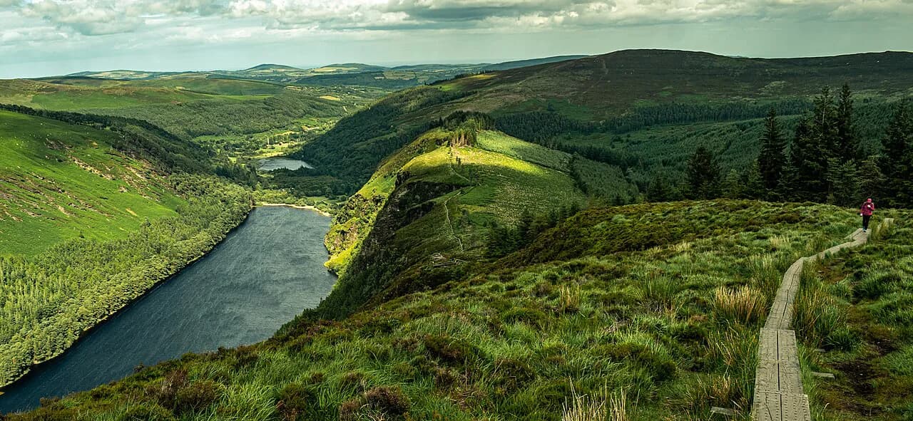
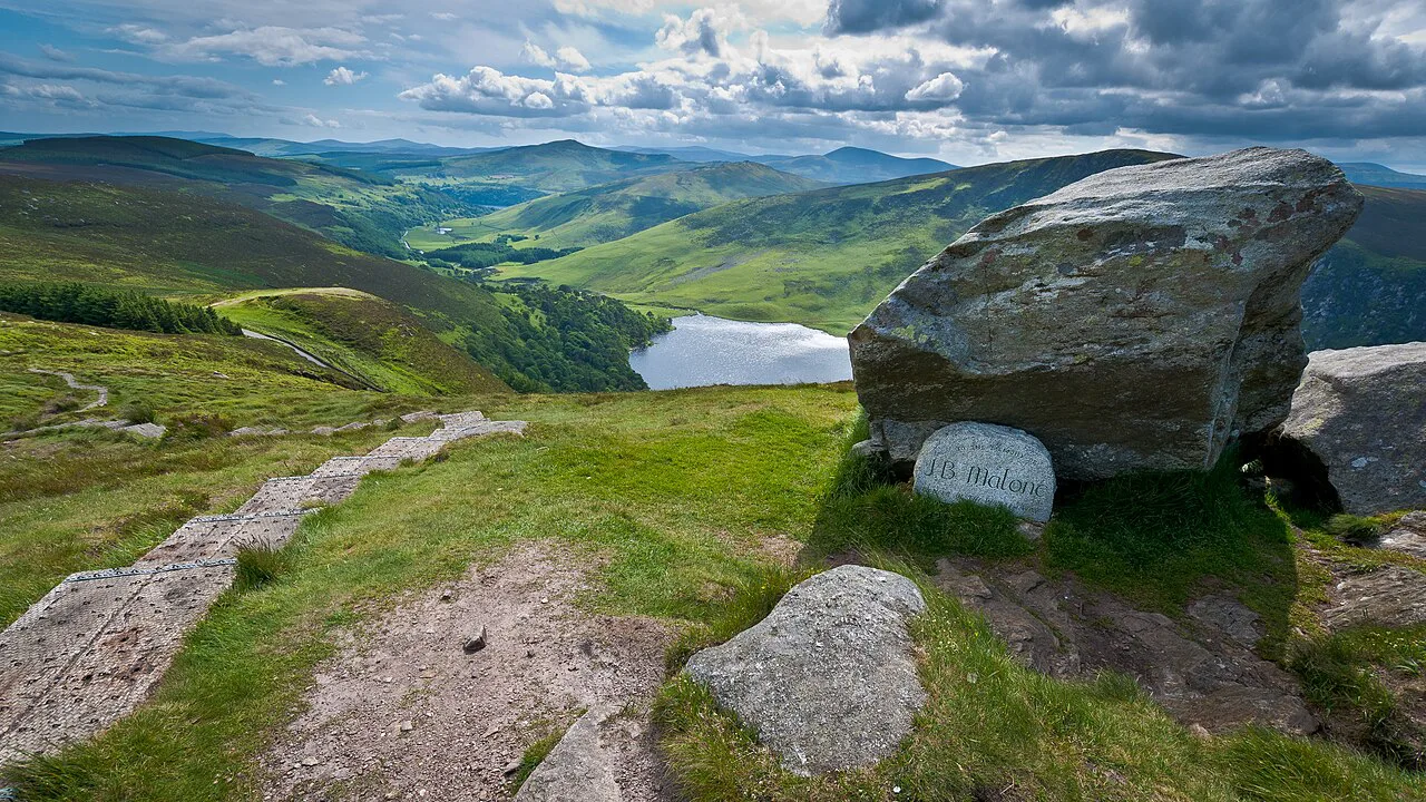
Between Roundwood and Glendalough the trail climbs Djouce and follows boardwalk above Lough Tay, one of the most photographed stretches of the route. The boardwalk protects the bog and keeps your pace up, but it is a narrow line across open hillside where wind and mist can arrive together, so keep a map and compass handy even though waymarking is frequent.
The descent into Glendalough brings you to the monastic site and the busiest stretch of the whole trail; the Roundwood to Glendalough day is short at 12 km (about 7.5 miles) precisely because most hikers want time there. This is the natural place to build in a rest half-day.
Glendalough to Glenmalure through the heart of the mountains
From Glendalough the route climbs back into open country and traverses toward Glenmalure, a glacial valley reached over mountain ground. At roughly 14 km with about 5 hours of walking, it is one of the shorter days but also one of the more remote, with fewer chances to cut the day short once you are above the valley floor.
Glenmalure is a valley base rather than a town, so treat it as a night stop and plan food accordingly rather than expecting a shop on arrival.
The southern stages: Glenmalure to Moyne, Shillelagh and Clonegal
South of Glenmalure the character changes: the trail leaves the high tops for forest roads, farmland and quiet lanes through Moyne and Shillelagh before the final approach to Clonegal. Days of 19–23 km (12–14 miles) with less than 600 m of ascent are typical here, so pace depends more on hard surfaces than on climbing.
Road sections are quiet but cars can travel fast on them, so walk facing traffic where you can and step off the tarmac when a vehicle approaches. A softer shoe or a change of socks for the forest track days makes a real difference over a week.
Waymarking, navigation and the road sections
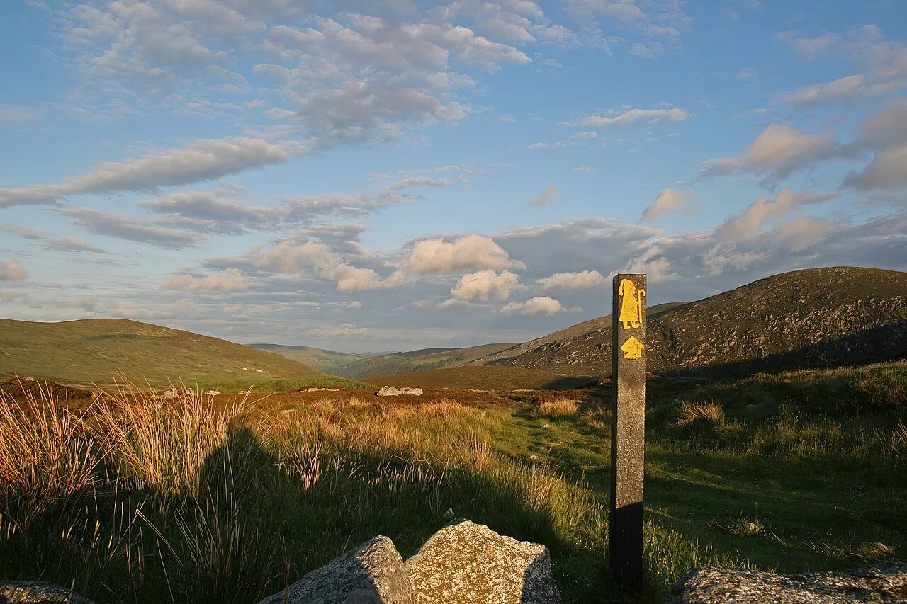
The way is marked with a yellow figure at junctions and at regular intervals along straight stretches, and information boards appear from time to time. If you have not seen a marker for more than a kilometer, stop and check the map rather than pressing on.
Carry an offline map on your phone, a power bank, and a paper Ordnance Survey map as backup; battery and signal both fail in the hills. The trail is straightforward to follow for most hikers, but mist on the open tops removes the landmarks you would otherwise use.
Huts, hostels and B&Bs along the way
There are B&Bs at the end of most stages and a handful in between, a hostel at Knockree and another at Glendalough, and three small Adirondack shelters on the trail intended for shelter from the weather. B&Bs and restaurants are limited outside the summer months, so book your nights before you commit to a route split.
Use the stage towns as your sleeping points: Enniskerry, Roundwood, Glendalough, Glenmalure, Moyne and Shillelagh all sit near stage ends, and staying slightly off the exact stage line gives you a shorter final day if the weather turns.
Wild camping and where it is not allowed
Wild camping is possible in many places along the Wicklow Way, and walkers camp beside the Adirondack shelters. Wild camping is not permitted in Glendalough Valley, so plan to stop before or after the valley.
Expect to adjust your day: a good pitch often turns up earlier than you planned, and sometimes you have to keep walking to find one. Campfires are not appropriate on farmland or bog, and everything you carry in should come out with you.
Food, water and resupply between stages
Towns are few and far apart, and there is no alternative to them for buying food, so carry enough for each stage plus a backup meal for breakfast, lunch and dinner. Water sources exist on most days but are not guaranteed, and water from streams and forestry is not always potable, so carry two to three liters and a filter.
Resupply at Roundwood, Glendalough and Shillelagh in particular, and treat the Glenmalure and Moyne stretches as carry-your-own-food days. A filter or purification tablets are lighter than extra water for the long 20 km days.
When to go: months, daylight and trail conditions
April to June and September are the best months: the forest tracks are dry and the open bog is firm underfoot. July and August are warmest but the Glendalough area fills with day walkers, and from November to February the bog holds water, daylight is short and some accommodation closes for the season.
May to September is the reliable window for a full crossing, and May or September give you fewer people on the trail and quieter stops at places like Powerscourt Waterfall and Glendalough. Outside summer, check that your planned accommodation is actually open.
Weather, exposure and bog underfoot
The Wicklow Mountains are exposed in places, weather changes quickly, and the combination of wind, rain and cold is the real hazard rather than the terrain itself. Carry layers, avoid cotton, and keep a warm dry set of clothes for the evening.
Bog sections hold water from autumn through spring, so expect wet feet and slower going on the open stretches above Glendalough and Glenmalure. Gaiters and waterproof boots are worth the weight; trail runners are fine in a dry June.
Luggage transfer and walking the trail in stages
You do not need to carry everything: most B&Bs and local transport companies can move a bag to the next town for a fee, which turns the route into a series of day walks with a light pack. Ask your accommodation when you book, since not every provider offers it.
Walking the trail in stages also suits hikers based in Dublin, since County Wicklow is close enough for individual days out. Pick the stage that matches your fitness; the Roundwood to Glendalough day is the shortest at 12 km and the Roundwood to Glenmalure stretch the longest at 27.2 km.
Short day sections for a single hike
If you only have a day, the Roundwood to Glendalough section gives you Djouce, the Lough Tay boardwalk and the monastic site in about four hours of walking, and it is easy to arrange transport back from Glendalough. The Marlay Park to Knockree day is a good city escape with a bus back into Dublin.
For a bigger single day, the Glenmalure to Moyne stage packs 21 km and the crossing of open ground into one long outing, but transport at both ends is harder, so it suits a hiker with a lift or a friend driving.
What to pack for a week on the trail
Footwear with good outsoles and support, trekking poles, and a layering system of merino or synthetic fabrics are the core of a Wicklow Way kit. Add a waterproof shell and overtrousers, a warm dry set for the evening, a filter, a power bank and paper maps.
Keep your phone and power bank charged each evening, start early to take pressure off the longer days, and pack out everything you bring. The route is a working landscape of farmland and forestry, so close gates and give livestock room.
Plan Your Visit
The Wicklow Way works best as a seven-stage week with a rest half-day at Glendalough, or as a six-day push if your schedule is tight and you can handle repeated long days. Start at Marlay Park by bus, finish at Clonegal via Kildavin, and book your beds before you commit to a split.
Compare it with other Irish routes before you decide: the Kerry Way and the Causeway Coast Way offer very different terrain and logistics.
Frequently Asked Questions
How long does the Wicklow Way take to hike?
Most hikers take about a week. A seven-stage plan runs from Marlay Park to Clonegal in daily stages of roughly 4 to 8 hours, while a six-day plan puts in longer days of up to 9 or 10 hours. Shorter splits are possible by combining or skipping sections.
Where does the Wicklow Way start and finish?
It starts at Marlay Park in south Dublin and finishes at Clonegal in County Carlow. The route crosses the Wicklow Mountains and passes Glendalough and Glenmalure along the way.
How do you get to the start of the Wicklow Way without a car?
Dublin Bus route 16 runs from Dublin city center to Marlay Park. At the far end, Bus Éireann stops in Kildavin, about 3 km from Clonegal, so the final link is a short walk or a lift. Check current times before you travel.
Can you wild camp on the Wicklow Way?
Wild camping is possible in many places along the route and beside the Adirondack shelters, but it is not permitted in Glendalough Valley. Plan your day so you can stop before or after the valley.
What is the best time of year to hike the Wicklow Way?
April to June and September give the best conditions, with drier tracks and firmer bog. July and August are warmer but busier near Glendalough, and winter brings short daylight and some closed accommodation.
Which direction should you walk the Wicklow Way?
North to south gives the easiest transport at the start and a quiet country finish. South to north eases you into the hills with gentler early days and ends with views over Dublin and the coast before the descent to Marlay Park.
Are there huts on the Wicklow Way?
There are no staffed mountain huts, but three small Adirondack shelters along the trail give emergency shelter. Hostels at Knockree and Glendalough and B&Bs in the stage towns provide the usual overnight stops.
Is the Wicklow Way suitable for a first long-distance hike?
Yes, for a hiker with decent fitness. Gradients are rarely steep, the route is well marked and towns break up the days, but the open tops are exposed to wind and rain, so pack for fast-changing weather.
Sources
Trail notes for your next trip
Optional updates when we add or revise hiking guides.
You might also like
Continue reading
More guides you'll find useful