Aletsch Glacier Hike: Route, Lifts and Distance Guide
Plan the Aletsch Glacier hike in Valais: the 12 km panorama trail from Moosfluh to Fiescheralp, lift access, ascent, walking time and the best months to go.
On this page
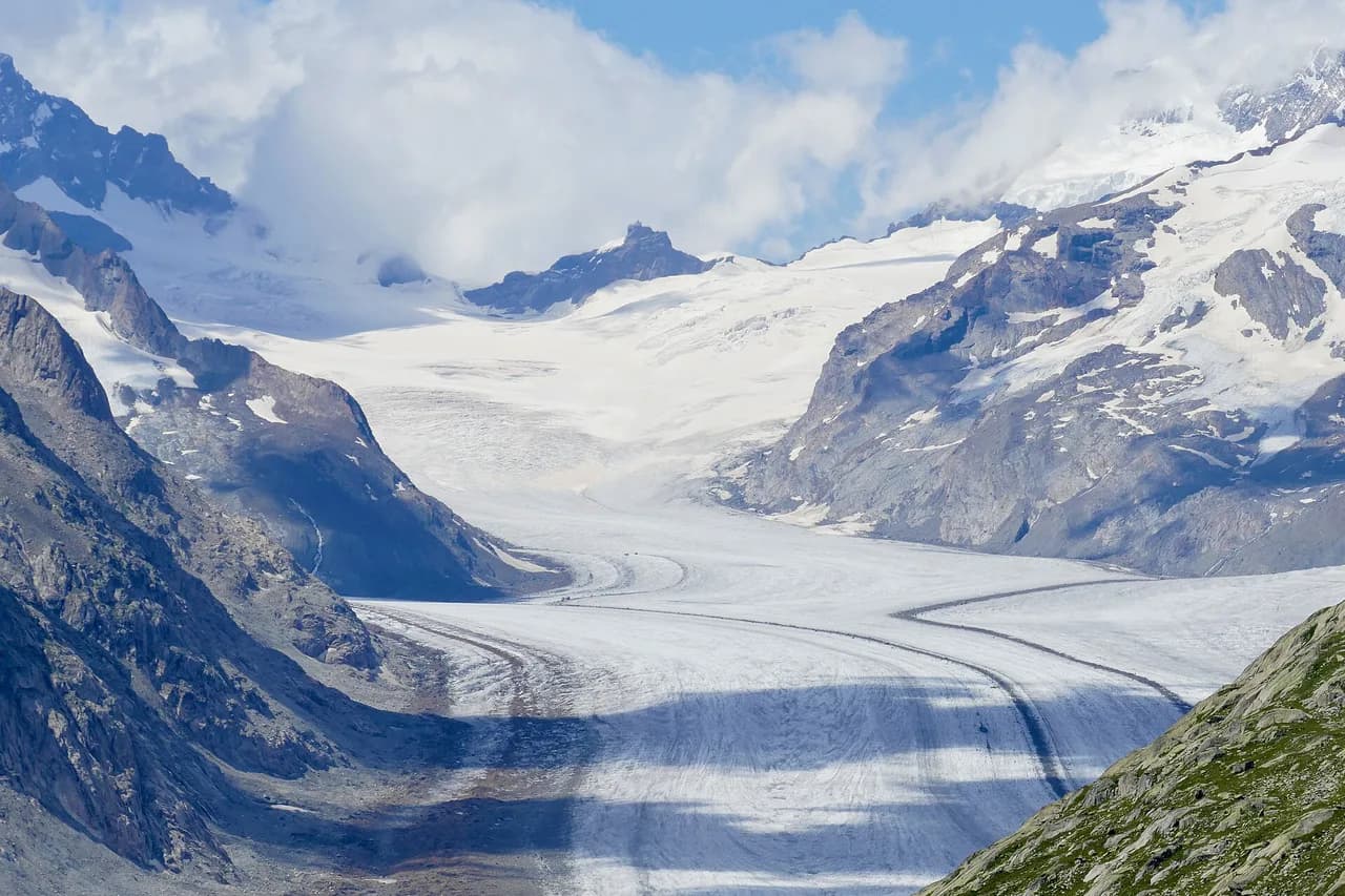
The Aletsch Glacier hike delivers the biggest ice flow in the Alps in a single day, viewed from a high trail that stays above the ice rather than crossing it. The glacier runs down from the Jungfrau region into Valais inside the Jungfrau-Aletsch UNESCO World Heritage site, and the walking is steady rather than technical. That combination suits fit day hikers who want a long, view-heavy outing without ropes, crampons or glacier travel.
Two shapes of day work best. The classic one-way route runs from the Moosfluh lift station above Riederalp to Fiescheralp in roughly 12 km (7.5 mi) with 510 m (1,673 ft) of ascent, while a longer loop around Bettmerhorn and Eggishorn stretches to about 16.4 km (10.2 mi) with roughly 830 m (2,723 ft) of climbing. Choose the first if you want a relaxed pace and time for photography; choose the loop if you want the glacier from tongue to origin in one continuous arc.
Trailhead and lift access
You cannot drive to the glacier or to the start of the walk. The approach is by lift from the valley villages, with the main access points at Fiesch, Betten and Mörel-Filet, each connecting to a car-free resort on the terrace above the Rhône. From Riederalp the Moosfluh gondola puts you at the official start point of the panorama trail, a few minutes from the Bettmerhorn upper station.
At the eastern end, Fiescheralp is served by its own lift from Fiesch and is the finish point of the one-way route. Park at the valley station of whichever lift you plan to use, since the villages themselves are car-free and reached only by cable car. Lift fares and summer operating dates change by season, so buy tickets from Aletsch Bahnen AG or at the valley station rather than relying on old figures.
If you want to shorten the climb, ride up to Moosfluh and walk the traverse to Fiescheralp, then descend by lift. Doing the route this way keeps the glacier on your right for most of the morning and avoids a long up-hill finish at the end of the day.
Taking the train to the valley
The Matterhorn-Gotthard Bahn stops at the valley stations in Fiesch, Betten and Mörel-Filet, which makes a car-free day genuinely practical. From the platform you walk to the cable car, ride up to the resort, and start the trail from the top station.
Allow time for the two-stage ascent before you set off, because the lifts run on their own schedule and the last descent of the day is the constraint on a long loop. If you are linking the Aletsch day into a wider trip, the Swiss rail network covers most of this region and the hiking in Switzerland guide has more on how the valleys connect.
The classic route: Moosfluh to Fiescheralp
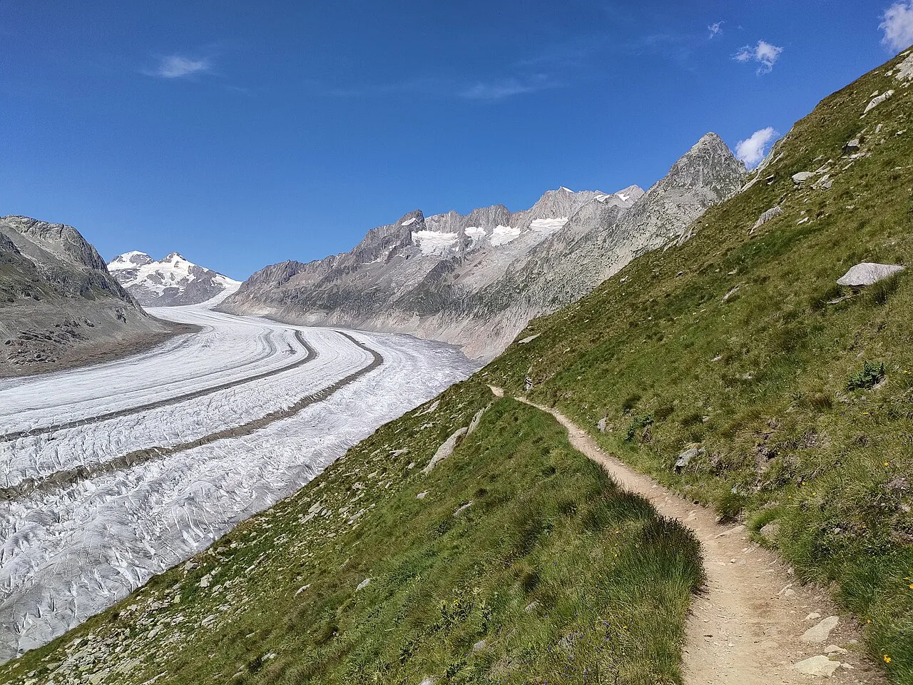
The panorama trail begins with stone steps climbing away from the Moosfluh upper station, gaining height quickly before the path eases into a traverse. It crosses the Grosses Gufer glacier remnant and then drops toward Rote Chumma, where the wide mountain trail is carved into the rock. On a hot summer day the cold air coming off the ice is a welcome part of the walk.
The path then runs to Märjelensee, a small lake once held back by a wall of glacier ice and now a quiet sheet of water in a postcard setting. The Gletscherstube restaurant at the lake serves apple tart baked in a wood-fired oven, which makes a natural lunch stop before the final stretch.
From the lake you either take the trail around the Tälligrat for views of the Fieschergletscher or use the shortcut, which saves about an hour. Both lines meet the illuminated Tälligrattunnel, and beyond it a wide trail leads down to Fiescheralp. The ridge option is the better choice if the weather is clear, since the Fieschergletscher is the second-longest glacier in the Alps and gets far less attention than its neighbour.
Distance, ascent and time on the panorama trail
The published figures for the Moosfluh to Fiescheralp route are 12 km (7.5 mi), 510 m (1,673 ft) of ascent and 630 m (2,067 ft) of descent, with a walking time of about 3 hours 45 minutes. Technical and physical demands are both rated medium. That time assumes steady walking and short stops, so add an hour or more for photography, lunch at the lake and the ridge detour.
The route is one way, starting at the Moosfluh upper station and finishing at the Fiescheralp upper station. It is not a circuit, so plan your descent from Fiescheralp rather than expecting to return to Riederalp on foot. Hikers who want the classic Bettmerhorn to Märjelensee line will find it rated among the best walks near the glacier.
The long loop around Bettmerhorn and Eggishorn
The circular version starts at Fiescheralp and works around Bettmerhorn and Eggishorn, covering about 16.4 km (10.2 mi) with roughly 830 m (2,723 ft) of ascent and descent. Expect 5.5 to 6.5 hours of walking, with a maximum altitude near 2,660 m (8,727 ft) if you stay on the traverse. The route visits the Bettmerhorn viewing platform before resuming the circuit.
Walk it clockwise. Going that way puts the glacier directly in front of you for most of the morning: you begin with the tongue, then the ice opens up toward Concordiaplatz and the Jungfraujoch as you round the far side. Anti-clockwise, the best views sit behind your shoulder for the first half of the day.
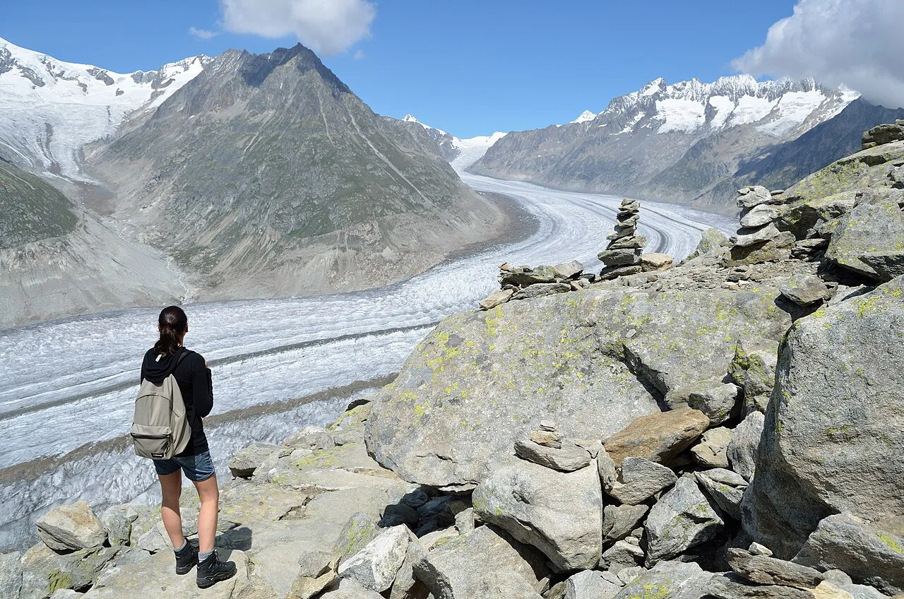
Near the far turn there is a descending path toward the glacier edge, where you can get close to the ice and appreciate its scale. Stay clear of fractured or overhanging blocks, which can collapse without warning. From there the loop closes back toward Fiescheralp through the Tälligrattunnel, with a seat view of the Fieschergletscher on the way.
Adding the Eggishorn summit
From Fiescheralp you can either walk up the Eggishorn or ride the cable car to the viewpoint. The cable car stops at the viewpoint, and the true summit is a further 20 minutes on foot over easy but rocky ground. From the top, the widest panorama of the whole glacier is laid out in one sweep, including the far side toward the Jungfraujoch.
Hiking up instead of riding adds roughly 700 m (2,297 ft) of ascent and two to three hours to the day. The Eggishorn cable car also runs early sunrise trips with a breakfast buffet, which suits photographers who want sidelight on the ice rather than the flat light of midday.
Huts, restaurants and water on the route
Food and drink are available at several points along the panorama trail: the Gletscherstube at Märjelensee, and Restaurant Kühboden and Restaurant Alpina at Fiescheralp. The route is not a remote wilderness traverse, so you can travel with a lighter pack than on a high alpine crossing.
There is no hut-to-hut structure on the Aletsch traverse itself, because both ends are lift-served and the villages above the valley have beds. If you want a multi-day mountain itinerary with booked huts, look at a dedicated hut to hut hiking switzerland route instead of stretching this day walk.
Carry at least a litre of water per person even with the restaurants open, since the middle section between Bettmerhorn and the lake is exposed and has no reliable refill. Fill bottles at your accommodation or the lift station before heading up.
When to go
The published season for the panorama trail runs from July to October. Early and late in that window, snow can linger on the shaded passages and on the descent toward the lake, so check trail conditions at the local information centre before committing to the full traverse.
Midsummer gives the longest days and the most reliable lift service, but afternoon thunderstorms build quickly over the ridge. Start early, aim to be off the exposed sections around the Tälligrat by early afternoon, and keep the shortcut in reserve if cloud arrives.
Autumn is quieter and often clear, with fresh snow on the highest ground that can make the rocky step sections slippery. Cotton grass meadows around Märjelensee are at their best in spring, though the through-route may not be open that early.
Exposure, weather and glacier ice
The trail is exposed in places, with steep drops below the path around the Bettmerhorn and Tälligrat sections. Sections are narrow and require surefootedness, and the route may be blocked or interrupted depending on season and weather.
Do not step onto the glacier itself or onto loose ice at the edge; the safe viewpoint is always from the trail. Fog and low cloud can obscure the route markers on the upper traverses, and a map and compass remain useful even on a marked path.
None of this is a technical climb and no harness or via ferrata kit is needed; the demands are distance, altitude and weather. If you want vertical ground with fixed cables, the switzerland via ferrata guide covers routes graded for beginners and experienced climbers.
Where to base yourself
Riederalp, Bettmeralp and Fiescheralp are the three car-free bases on the terrace above the glacier, all reached by cable car. Bettmeralp puts you closest to the Eggishorn end and the finish of the long loop, while Riederalp gives the shortest ride to Moosfluh and the start of the panorama trail.
Staying up on the terrace means a short morning transfer to the trailhead and the chance to walk at sunrise before the day visitors arrive. Staying in the valley is cheaper and gives easier access to the rail line, but adds a lift ride at each end of the day.
For a longer Valais trip, the Tour de Monte Rosa is the natural next step into bigger terrain, with multi-day walking between mountain villages rather than a single lift-served traverse.
Gear and fitness
Treat this as a long high-altitude day walk rather than a stroll: broken-in boots with grip for rocky steps, layers for cold wind off the ice, sun protection and a waterproof shell. Trekking poles help on the long descent to Fiescheralp and on the loose sections below Bettmerhorn.
The one-way route suits hikers comfortable with six to eight hours on their feet including stops; the full loop demands more, particularly if you add the Eggishorn summit on foot. Build in a rest day if you are arriving from low altitude, since the trail stays above 2,000 m (6,562 ft) for most of its length.
The route beyond the destination
For guided and self-guided options elsewhere in the country, including multi-day packages with luggage transfer, the Switzerland hiking tours pages cover what each format includes. Beyond the Aletsch area, the Bernese Oberland holds the classic high routes around Grindelwald and Wengen, but those belong to a separate trip and a separate set of lifts; for that trip, this hiking in Grindelwald guide covers the trails, lifts and how hard they are.
Plan Your Aletsch Glacier Day
Pick the one-way Moosfluh to Fiescheralp traverse if you want a manageable day with time for the lake and the viewpoints, and take the Bettmerhorn to Eggishorn loop if you want the whole glacier in a single arc. In both cases, ride up in the morning, keep the glacier in front of you, and leave margin for the last descent.
Book your bed in Riederalp, Bettmeralp or Fiescheralp before you travel, since the car-free villages fill in summer. Then buy your lift ticket at the valley station and confirm the day's conditions with Aletsch Bahnen AG, because the upper sections can close at short notice.
Frequently Asked Questions
How long is the Aletsch Glacier hike?
The classic one-way panorama trail from Moosfluh to Fiescheralp covers 12 km (7.5 mi) with 510 m (1,673 ft) of ascent and about 3 hours 45 minutes of walking. The longer circular route around Bettmerhorn and Eggishorn runs about 16.4 km (10.2 mi) with 830 m (2,723 ft) of climbing and takes five and a half to six and a half hours.
How do you get to the Aletsch Glacier trailhead?
Take the Matterhorn-Gotthard Bahn to Fiesch, Betten or Mörel-Filet, then ride the cable car up to the car-free villages. Moosfluh, above Riederalp, is the start of the panorama trail, and Fiescheralp is the finish; the Eggishorn lift serves the summit viewpoint.
Can you do the Aletsch Glacier hike without a cable car?
You can walk up from the valley, but it adds a great deal of climbing to an already long day. Most hikers ride up to Moosfluh or Fiescheralp and walk the traverse between them, which keeps the day within a normal walking window.
What is the best month for the Aletsch Glacier hike?
The published season runs from July to October. Midsummer gives the longest days, while September and early October bring clearer air and fewer walkers; snow can lie on shaded passages at either end of the season.
Which direction should you walk the long Aletsch loop?
Walk it clockwise. That way the glacier sits in front of you for most of the morning, starting with the tongue and opening toward Concordiaplatz and the Jungfraujoch as you round the far side.
Is the Aletsch Glacier hike difficult?
It is rated medium for both technical and physical demands. There is no glacier travel or scrambling, but the trail is long, stays high, and has exposed sections that require surefootedness when wet or snowy.
Sources
Trail notes for your next trip
Optional updates when we add or revise hiking guides.
You might also like
Continue reading
More guides you'll find useful