

Helvellyn Walk via Striding Edge: Route, Distance and Time
A Glenridding circuit to Helvellyn's summit via Striding Edge and down Swirral Edge, with distance, ascent, walking time and ridge exposure explained.
On this page
Helvellyn rises to 950 m (3,117 ft), England's third-highest summit, and the circuit from Glenridding pairs it with two knife-edge ridges: Striding Edge on the way up and Swirral Edge on the way down. The full round is 12.4 km (7.7 miles) with 828 m (2,717 ft) of ascent and 5 to 6 hours of walking, rated challenging. It suits hill walkers who are comfortable using their hands on rock and who want a big mountain day rather than a gentle fell stroll.
The crux of the day is not the summit but a rock tower on Striding Edge that has to be down-climbed with care, facing into the rock. Walkers who would rather not commit to that can take a straightforward bypass path to the right of the rocky crest, or skip Striding Edge altogether and climb by Swirral Edge. If you are still choosing which fell fits your trip, this guide sits within the wider picture of hiking in Lake District national park country, where valley starts and ridge lines vary enormously in seriousness.
Distance, ascent and time
The round trip from Glenridding covers 12.4 km (7.7 miles) with 828 m (2,717 ft) of ascent and takes most walkers 5 to 6 hours, and it is graded challenging. That time includes the slow work on the ridges, where progress is measured in careful steps rather than pace. Plan on a full day out and start early enough to be off the exposed ground well before evening. If you are weighing this against other long ridge days in Britain, hiking in Scotland offers a useful comparison of distance and seriousness.
The figures describe the Glenridding circuit only; other approaches to the summit follow different lines and different distances. Treat the 828 m as total ascent for the day rather than the height of the mountain above the village, and carry that distinction into your timing. The height itself is 950 m (3,117 ft), which sits behind the figures rather than replacing them.
Trailhead and parking at Glenridding
The route starts and finishes at Glenridding's main car park on the A592. Leave the car park, turn right along the road and immediately right again, then fork right beside the beck; at a minor road go left and pick up a gravel path on the right. Keep left at a path junction near a gate and bear right at the next fork. Returning at the end of the day, turn right after the Fairlight Guesthouse to re-enter the car park.
Parking charges and opening times at Glenridding's main car park are set locally, so read the notices on the day rather than budgeting on hearsay. Glenridding is the practical base for this circuit because the route leaves and returns to the same village center. Patterdale, a short distance down the valley, gives a quieter night with the same early start.
Getting there without a car
Glenridding sits on the A592 beside Ullswater, and the classic circuit needs no lift or cable car: everything is on foot from the village. Walkers arriving by public transport typically come via Penrith or Windermere and connect onward to the Ullswater valley, but timetables and service numbers change by season. Before you commit, the local tourist information service can confirm which services run on your dates and how late the last return leaves.
If you are coming by train, allow for the connection at the end of the line rather than assuming a bus meets every arrival. A car-free day here works best when you have a confirmed return service in hand before setting off up the valley. Staying in Glenridding or Patterdale removes the connection entirely.
Route description: Glenridding to the foot of Striding Edge
From the village the path climbs steadily, and the first reward is the view of the pyramid-shaped Catstye Cam with Helvellyn's cliffs behind it. After the next gate, turn left and the real ascent begins. Soon after passing, and ignoring, a ladder stile in the wall, join a path from the left that leads onto Striding Edge.
This opening climb is a sustained pull rather than a technical one, so settle into an even rhythm and keep something in reserve for the ridge. The ridge section arrives quickly once you are on the crest, and the character of the day changes with it.
The Striding Edge ridge
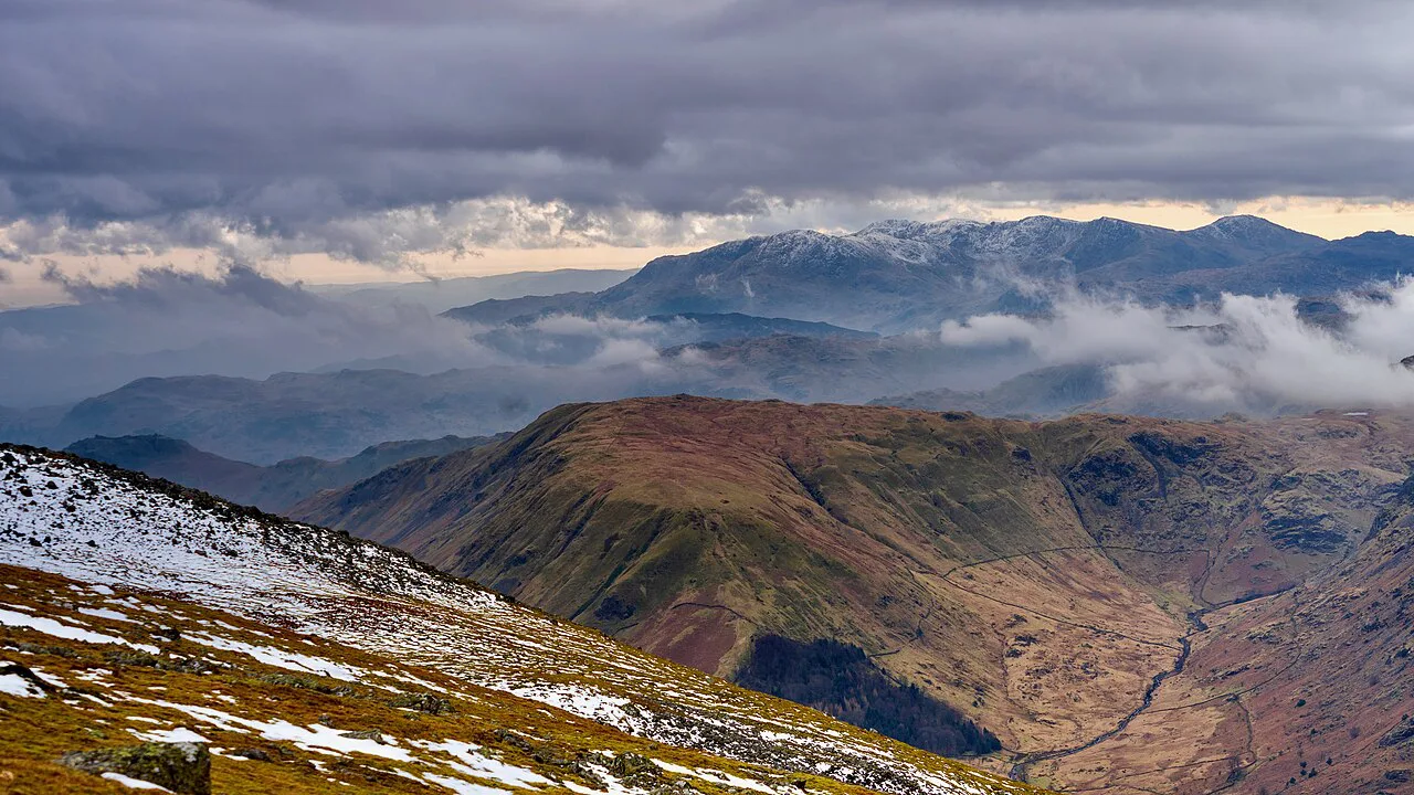
On the crest you have a choice: follow the exciting rocky apex, scrambling easily over one or two small dips, or take the more straightforward path to the right. The biggest difficulty is a rock tower that must be down-climbed with care, facing into the rock. Take a breather after it before the final, lung-bursting pull to the summit plateau.
The bypass line is the sensible pick in wind, wet rock or low confidence, and it keeps the day a walk rather than an exposed scramble. The crest is best tackled in dry, calm conditions and only by those with a head for heights. For a closer look at the ridge and its rock steps, the dedicated Striding Edge route guide breaks down the same ground.
The summit plateau
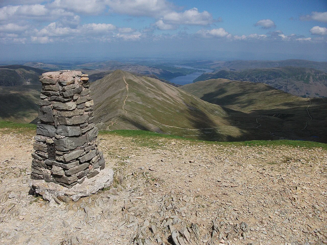
At the top, bear right along the plateau's edge and pass the memorial to Charles Gough before reaching the summit shelter and the trig pillar. The plateau is extensive, big enough that two airmen landed a plane on it in 1926. On a clear day the outlook takes in all of Lakeland plus the North Pennines and some Scottish hills.
Navigation on the plateau deserves attention because its edge features repeat and mist can erase the horizon. Note the line you want for Swirral Edge before you leave the trig pillar. Helvellyn is one of the Lakeland fells catalogued by Alfred Wainwright, and fell-baggers often pair the summit with neighbouring tops on a separate day.
Descent by Swirral Edge and Red Tarn
Keep to the fell edge to find the sprawling cairn that marks the path onto Swirral Edge, then carefully descend right to negotiate the rocky ridge. About 500 m after leaving the plateau, fork right and descend toward Red Tarn, then fork left to drop into the valley of Glenridding Beck, crossing two tributary bridges. Bear left over a bridge on Glenridding Beck and turn right along a track near Greenside's converted mine buildings.
The valley track past Greenside closes the circuit on a steady line rather than a retraced ridge, which is easier on tired legs and knees. Red Tarn sits in dramatic ground below the crags, so allow a few minutes there rather than pushing straight through. From Greenside the track runs back toward Glenridding and the car park.
Exposure, scrambling and conditions
Striding Edge and Swirral Edge are exposed ridges and are best tackled in dry, calm conditions by walkers with a head for heights. The rock tower down-climb is the point where that exposure is most concentrated. Wind and wet rock raise the stakes on both ridges, so be ready to take the bypass path or turn back rather than forcing the crest.
In winter conditions, mountaineering gear and experience are essential on these ridges. Snow and ice on the edges and the plateau change the day from a scramble into a winter climb. Treat any forecast of strong wind or poor visibility on the tops as a reason to choose a lower route.
Swirral Edge as an alternative ascent
Walkers who want Helvellyn's summit without Striding Edge can climb by Swirral Edge instead, reversing the described descent line. It is the shorter, steeper approach to the plateau, and it still delivers rocky ground and exposure near the top. From the summit you can return the same way or drop to Red Tarn and follow the valley track back to Glenridding.
This variation keeps the day within the same distance ballpark and gives you the ridge experience in a more contained form. It also makes a sensible bad-weather plan if the forecast improves late in the day.
When to go
The circuit is a summer and early-autumn outing at heart, when daylight comfortably covers 5 to 6 hours on the hill and the rock is dry. Late spring and early autumn can be quieter than high summer, but snow can linger on the edges and plateau well into the season. Check the mountain forecast for wind and cloud on the tops before you commit.
Afternoon storms are a real feature of Lakeland summers, and the plateau and ridges are no place to be caught in one. An early start gets you off the exposed ground before the weather builds. Short winter daylight makes a full circuit impractical for most walkers.
What to wear and carry on a Grade 1 scramble
Wear grippy boots with a firm edge and bring a small pack that sits close to your back; you will use your hands on the crest and the rock tower. Carry water and food for a five- to six-hour day, plus a waterproof shell, a warm layer and a map and compass for the plateau. A helmet is not standard for this grade, but a guide is worth considering if you are new to exposed ground.
Gloves help on cold rock, and a phone battery pack is a sensible addition for a long day out. Pack for the descent as well as the climb: tired legs on Swirral Edge need the same care as fresh ones on Striding Edge.
Where to stay in Glenridding and Patterdale
Glenridding puts you within walking distance of the car park and the route's start, which matters for an early departure. Patterdale, a short distance down the valley, offers a quieter base with the same access to the circuit. Book ahead for summer weekends, when the Ullswater valley fills up.
Either base works for a second day on the fells, and the valley has lower-level walks if the tops are clouded. Staying two nights gives you a weather window rather than a single fixed date.
Nearby alternatives outside the circuit
If the tops are out of condition, the Aira Force to Raise walk gives a lower-level day beside the waterfalls and woods of the Ullswater valley, and the Howtown to Glenridding walk follows the lake shore. The Catbells walk above Derwent Water is a shorter ascent with big views for a gentler day. Both sit outside the Helvellyn circuit but within the national park.
The Aira Force Walk guide covers the waterfall paths in more detail if you want a family-friendly backup. The Wainwrights list is a useful way to plan a longer season of fell days around Helvellyn.
Plan Your Day on Helvellyn
The Glenridding circuit is the classic way to climb Helvellyn: 12.4 km (7.7 miles), 828 m (2,717 ft) of ascent and 5 to 6 hours, with Striding Edge's rock tower as the crux and the Swirral Edge descent closing the loop. Decide in advance whether you want the exposed crest or the bypass path, and pick a dry, calm day.
Start early from Glenridding, carry for a full day on the hill and keep an eye on the forecast for the tops. If conditions turn, the valley walks around Ullswater give you a good day at lower level instead.
Frequently Asked Questions
Is the Helvellyn walk from Glenridding a hard hike?
Yes, the 12.4 km (7.7 mile) circuit with 828 m (2,717 ft) of ascent is graded challenging. The difficulty comes less from the height than from Striding Edge, where the rocky crest, the bypass path and the rock tower call for a steady head and hands-on movement. Walkers with a reasonable level of fitness who are comfortable on rocky ground will find it a long but rewarding day.
How long does the Helvellyn walk via Striding Edge take?
Allow five to six hours of walking for the full round from Glenridding back to the village. The ridges slow progress, so that window covers the careful work on Striding Edge and Swirral Edge as well as the climb and the descent. Getting away early leaves margin for the exposed sections.
Can you walk Striding Edge without scrambling experience?
The ridge is best treated as a hands-on scramble rather than a simple path, so it suits walkers who are happy using their hands on rock with exposure beneath them. If that is not you, a more straightforward path runs to the right of the rocky apex, and Swirral Edge offers an ascent without Striding Edge. Pick the line that matches your confidence before you reach the crest.
Sources
Trail notes for your next trip
Optional updates when we add or revise hiking guides.
You might also like



Continue reading
More guides you'll find useful





